
BasicShell

 Search
 000973510100006
|
|
-
Owners


Type Owner Ownership
Dates909940697
Deed
PrimaryJarrett, Ty
2820 310th Ave
Dickens IA 51333-7542Start 12/22/2020
End
Legal Descriptions
Description2.05 AC TR PT NW NW BEING 208.52' X 314.10' BEING PARCEL A
Value
Property Value Description Type & Category Value Taxable Acres CSRs Dwellings
&UnitsReason Land Land - Taxable 43,460 20,141 1.55 .00 0 - 0 Buildings & Residential Dwellings Building - Taxable 187,340 86,819 .00 .00 1 - 0 Exempt Road Acres Land - Exempt 0 0 .50 .00 0 - 0 Total 230,800 106,959 2.05 1 - 0
Application
Credits and
ExemptionsDate Number
Book-PageEnlisted
DischargedSmoke
Allow - RemovedEntity
ClaimantHomestead Tax Credit
H01/07/2021
2020 - 4085
Y
Y -909940697 - Jarrett, Ty
Jarrett, Ty
Recorded Documents
Grantor:1/Grantee:2
Type NameDocument Type
Legal DescBook
Page
Rec. Date
Inst. Date
Document2 Jarrett Ty
1 Nisland Asset Investments LlcTown Lot Warranty Deed 
2020
408512/22/2020
12/07/20204085 1 Numa Property Management Llc
2 Nisland Asset Investments LlcLand Warranty Deed 2020
269909/02/2020
09/02/20202699 2 Numa Property Management Llc
1 Hoogeterp Andrew Jon
1 Hoogeterp Taylor
1 Clay County Sheriff
1 Roundpoint Mortgage Servicing Corp
1 Home State Bank
1 Aaa Collections Inc
1 Farmers Trust & Savings Bank
1 Iowa State OfLand Sheriff's Deed 2020
251708/21/2020
08/19/20202517 1 Ness Jeremy
1 Ness Traci
2 Hoogeterp Andrew J
2 Hoogeterp TaylorLand Warranty Deed 2018
121305/15/2018
04/26/20181213 1 Ferguson Jason L
2 Ness Jeremy
2 Ness TraciLand Warranty Deed 2005
423712/07/2005
11/23/20054237 1 Paul Mar Ltd
2 Ferguson JasonLand Warranty Deed
T97 R35 S10 N1/2 NW1/42002
82002/26/2002
02/26/2002820
Tax Receipts
Property Tax
Year PayableReceipt
Number1st Half
Date Due1st Half
Amount2nd Half
Date Due2nd Half
AmountNotes 2023/2024  138
13809/30/2023 0.00 03/31/2024 0.00 -
Tax Calculation 2023-2024
180,470 Assessed Value X Roll Back Factor8 98,627 = Net Assessed Value (54.6501 Percent) 0 - Mitary Exemption 98,627 = Taxable Value 0.02504061 X 2023 Levy Rate (2.504061 Percent) 2,469.68 = Gross Taxes Due 121.45 - Homestead Credit 0.00 - Ag Land Credit 0.00 - Family Farm Credit 0.00 - Elderly Credit 0.00 - BPTC (Business Property Tax Credit) 0.00 - Future Payments 2,348.00 = Net Taxes Due The assessed value is set by the assessor. The assessed value is multiplied by a rollback factor resulting in the Net Assessed Value.
8The rollback factor varies for each parcel, consequently it is not possible to display a single rollback percentage. (The County Auditor can supply the actual rollback(s) for each parcel.)
The Military exemption (eligibility requirements), if any, is subtracted from the Net Assessed Value giving the Taxable Value.
The Levy Rate (%) is set annually by the state. Gross Taxes Due are calculated by multiplying the taxable value by the Levy Rate.
From the Gross Taxes Due several credits may be given. These include the Homestead Credit, Elderly Credit (determined by income), Agriculture Land Credit, and the Family Farm, (percent of value) credits.
Finally, any future payments are subtracted from the Gross Taxes Due. This yields the Net Taxes Due which are rounded to the nearest even dollar. Taxes are payable in two installments due on Sept 30, 2012 and on March 31, 2013
Tax History
Tax History
Receipt
Value
Taxable
Tax Due
Homestead
Military
FamFm
AgLand
Elderly
BPTC2023/2024 00138180,470 98,627 2,348.00 121.45 2022/2023 00138167,960 90,917 2,186.00 123.14 2021/2022 00137164,730 92,923 2,146.00 118.21 2020/2021 00137143,900 79,252 1,740.00 113.49 2019/2020 00136123,170 70,106 1,492.00 110.82 2018/2019 00136123,170 68,508 1,572.00 2017/2018 00136115,210 65,599 1,472.00 2016/2017 00136115,210 64,086 1,470.00 2015/2016 00136113,800 63,425 1,414.00 2014/2015 00136113,800 61,908 1,340.00 2013/2014 00136114,840 60,655 1,358.00 2012/2013 00136114,840 58,283 1,322.00 2011/2012 00136115,850 56,222 1,290.00 2010/2011 00137115,850 54,344 1,252.00 2009/2010 00137102,510 46,733 1,080.00 2008/2009 00136102,510 45,187 1,012.00 2007/2008 0013595,890 43,687 936.00 2006/2007 0013586,400 40,502 874.00 88.78 2005/2006 0013568,170 33,348 680.00 87.07 2004/2005 00135 68,170 33,677 744.00 2003/2004 00134 50,620 26,737 568.00 2002/2003 00135 1,490 1,490 30.00 1.05
Tax Distribution
Taxing
AuthorityPercent of
Tax DollarsDollars
CurrentDollars
Last YearCounty Wide
CurrentCounty Wide
Last YearCounty Wide
Inc/DecPercent
Inc/DecGrae/terril Csd 55.410% 1,300.99 1,216.56 3,697,773.00 3,690,521.00 7,252.00 .196% County/co.wide 19.482% 457.44 420.30 5,863,703.00 5,748,924.00 114,779.00 1.996% Rural/suppl 15.512% 364.23 334.46 2,269,194.00 2,192,189.00 77,005.00 3.512% Merged Area 3 4.490% 105.43 95.61 8,486,628.00 8,211,242.00 275,386.00 3.353% Assessor 1.719% 40.37 38.34 517,511.00 524,358.00 -6,847.00 -1.305% Debt Service 1.673% 39.28 44.17 529,757.00 628,951.00 -99,194.00 -15.771% Ag Extension .899% 21.11 19.13 270,546.00 261,696.00 8,850.00 3.381% Lake .808% 18.98 17.22 8,227.00 7,819.00 408.00 5.218% Spec.dist/t.b. .007% 0.17 0.21 354,498.00 462,458.00 -107,960.00 -23.344% Tax Distribution Chart
Tax History Chart
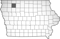
Map
Information current through close of business 04/28/2024
This site designed, developed, hosted and maintained by "Solutions", Inc.Disclaimer: Every effort is made to insure accurate information is posted to this site.
The server processed this request in 1.04 seconds
However, County does not warrant or guarantee the accuracy, reliability or timeliness of the content on this site or content which is referenced by or linked to this site.
Redistribution of data from this site for commercial purposes is strictly prohibited.
BISON
